Urban Exploration Platform
Built for explorers
to organize forgotten places.
UrbanLens is a private, purpose-built mapping platform for urban explorers, historians, and photographers who want to document forgotten places responsibly.
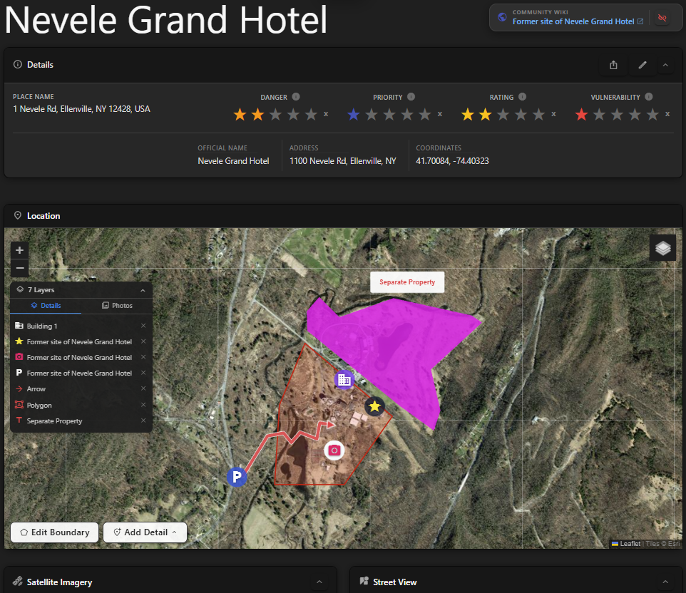
Your personal atlas.
Urban explorers accumulate knowledge - locations, access routes, structural notes, hazards, history - across years of fieldwork. That knowledge typically lives in scattered notes, private DMs, and memory. UrbanLens gives it a permanent, organised home.
Every pin you drop is yours, and stays that way until you act to share it. You decide what to share, who can see it, and how much detail is visible. The platform is built around the understanding that some places deserve to be documented without being advertised.
Privacy
Your pins are private. Granular visibility controls let you share selectively - with friends, with trip members, or with no one.
Communication
Each location has a community wiki for collectively recording history, access notes, hazards, and architectural details before they disappear.
Planning
Trip planning, RSVPs, and shared itineraries - coordinate expeditions with people you trust without exposing location details to the world.
One developer, not a company.
UrbanLens is built and maintained by one person. It started as a personal tool - a way to search, save, document, and share locations and research with a small circle of friends - and grew into the platform it is now.
The goal was never to launch a product. It was to make a place where one explorer and their friends could search, document, save, and share what they'd found - privately, deliberately, and on their own terms. That's still what UrbanLens is: a tool made by an explorer, for the people they explore with. It just happens to have room for you too.
Responsible by design.
Private by default
Every pin is private. Sharing is opt-in and granular - by friend, by trip, or not at all - so your pins don't go public by accident.
Hazard notes on every pin
Pins carry structural hazard notes and vulnerability ratings. We encourage users to record and share safety information, so they never explore alone.
A living archive
Every location gets a wiki page for history, architecture, and access notes - documentation that outlasts the building itself. Participation in the wiki is opt-in, always.
Built for your circle
Trip planning, RSVPs, and shared itineraries make it easy to loop in people you trust, without broadcasting a location to anyone else.
Safety tools
Features like safety check-ins, and immediate access to community research, make it easier to stay safe, and to get help when you need it.
No ads, no data sales
We don't sell location data or run ads. Pins, photos, and notes exist to run the platform - nothing else.
Curious what's behind these choices? Read our values.
Everything you need, nothing you don't.
Interactive map
Drop pins on any location worldwide. Add photos, notes, visit dates, priority ratings, and vulnerability assessments. Filter by tags and categories to find what you need instantly.
- Custom tags, categories, and status labels
- Satellite, street, and topographic base layers
- Priority & vulnerability star ratings
- GPS coordinates extracted from photo EXIF data
Community location wiki
Each physical location can have a shared wiki where the community documents history, architectural details, access notes, hazards, and more - without revealing coordinates to anyone who doesn't already know the location.
- Comments, research, history and notes
- Annotated maps with arrows, shapes, and labels
- Entirely separate from your personal pin
Trip planning
Organise group expeditions start-to-end. Add activities, invite members, collect RSVPs, and share itineraries - all without exposing exact pin locations to people who haven't been there yet.
- RSVP tracking and member management
- Per-trip privacy for location details
- Linked to pins for instant context
Photo management
Upload photos to see them on a map, and automatically create pins for them. Drag untagged photos onto the map to assign locations. Annotate maps with detailed markup visible in both thumbnails and full view.
- Opt-in: Automatic GPS extraction from EXIF metadata
- Drag-and-drop coordinate assignment on the map
- Per-photo visibility controls
Made for people who explore with intention.
Photographers
Track shooting locations, document access conditions, and build a private library of sites worth returning to.
Travelers
Log sites you've visited, rate their security and vulnerability, and share trip notes with your crew.
Historians
Build a living archive of endangered heritage sites with written histories, photographs, and architectural notes.
Explorers
Record structural hazards, asbestos risks, and structural conditions to keep your group safer on every visit.
Start mapping your world.
It's free, private, and built for people who explore with care.
rocket_launch Create an account